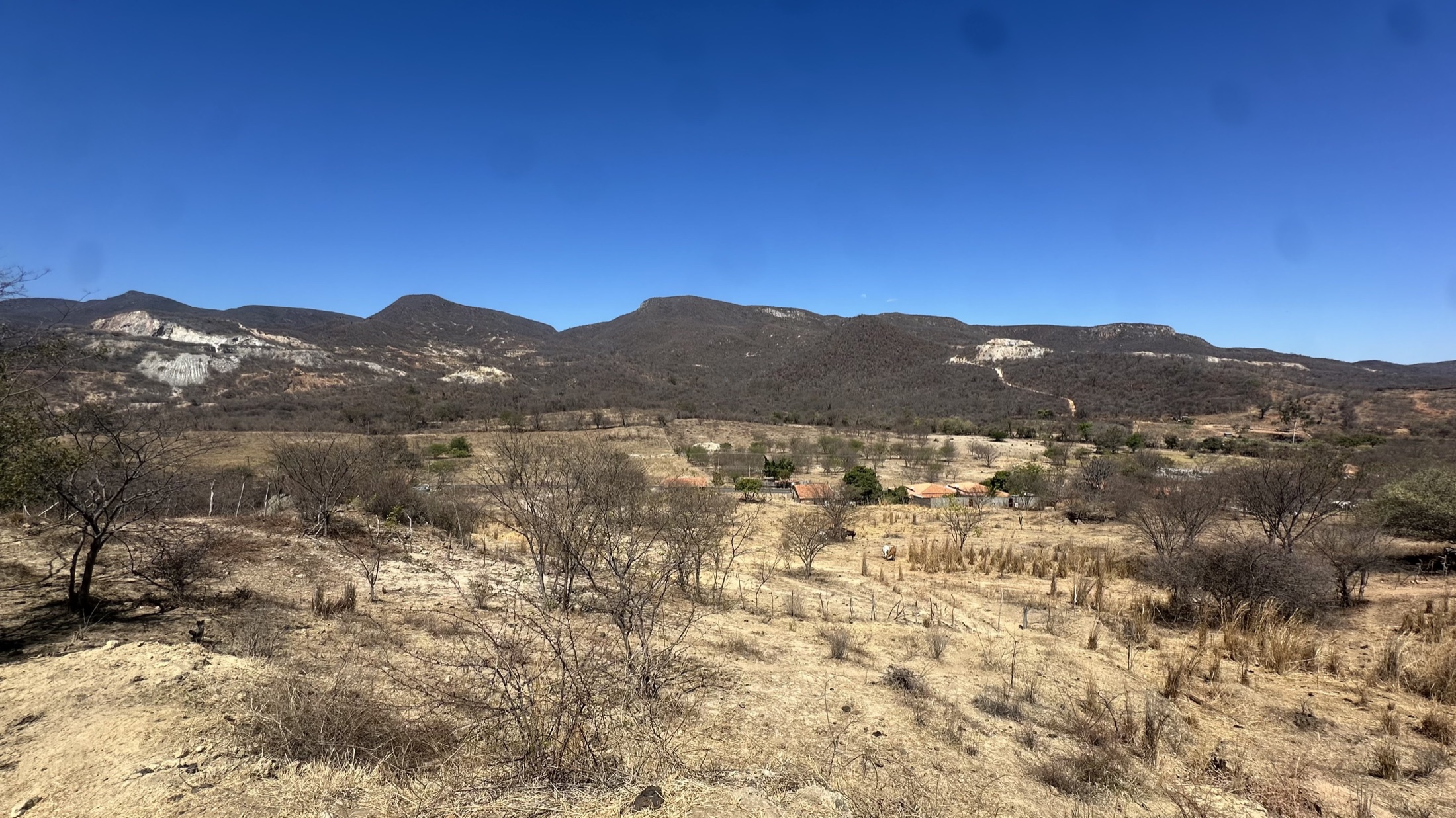
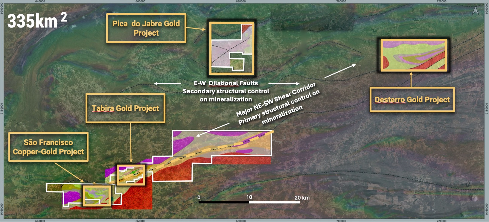
Alongside our flagship São Francisco copper-gold project, Prospectiva holds 100%-owned gold exploration ground across the Borborema Belt in northeast Brazil, a proven but underexplored orogenic gold province.
Gold mineralisation in the belt is hosted within major regional shear corridors, expressed at surface through quartz vein networks, artisanal workings and high-grade rock chip results. Historical work has confirmed the presence of high-grade gold, but drilling has been limited and shallow, leaving these systems largely untested at depth and along strike.
Three gold targets have been identified so far: Tabira, Pico do Jabre and Desterro.
Regional Setting
Tabira
GoldQuick Facts
- Ownership
- 100%
- Location
- Pernambuco State, Brazil
- Deposit style
- Structurally controlled, orogenic gold
- Historical work
- 5,531m diamond drilling
- Next work programme
- Detailed structural mapping
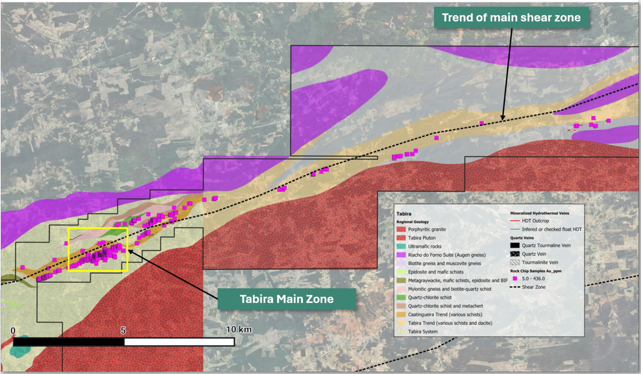
Tabira project geology, showing the regional shear corridor and mapped mineralised zones.
Historical exploration has defined a broad mineralised trend containing multiple quartz-vein corridors, hydrothermal alteration, anomalous gold and pathfinder geochemistry, and numerous historic artisanal workings. Detailed work has identified several subparallel vein systems within the main Tabira corridor, while the broader prospective shear system extends for approximately 30 kilometres.
Surface sampling has returned numerous high-grade gold results, including selective rock-chip assays of up to 436 g/t Au.1 Historical diamond drilling has also confirmed high-grade mineralisation below surface, including reported intersections of 1.75m at 12.89 g/t Au in TBS-002 and 0.50m at 47.20 g/t Au in hole TBS-019.2
Prospectiva is integrating the extensive historical geological, geochemical and drilling datasets with renewed structural interpretation. The next phase of work will focus on detailed structural mapping, validation of priority vein corridors and the ranking of targets for follow-up exploration and potential drilling.
Yamana Gold completed regional mapping, structural analysis, prospecting and first-pass geochemical sampling, identifying a structurally controlled gold system and major mineralised shear corridors.
Yamana Gold completed detailed mapping, extensive rock-chip and soil sampling, trenching and reconnaissance diamond drilling, which defined the Tabira mineralised corridor, high-grade surface results and confirmation of mineralisation below surface.
Yamana Gold completed surface geochemistry, XRF screening and RAB drilling, expanding the regional target pipeline and identifying additional gold-bearing hydrothermal corridors.
Yamana Gold completed soil geochemistry, geophysics, structural targeting and further diamond drilling, enabling refinement of the structural model and further testing of Tabira and surrounding gold targets.
Pan American Silver maintained the licence ownership and historical technical database.
Prospectiva Resources acquired the licence and completed data validation, geological review, structural interpretation and target ranking.
Geological Setting
Tabira is located within the Borborema Province, a highly deformed Neoproterozoic orogenic belt comprising metamorphosed volcanic, sedimentary and intrusive rocks affected by multiple phases of deformation.
The project area contains interlayered metavolcanic and metasedimentary units cut by granitic intrusions and regional brittle-ductile shear zones. These structures provided pathways for hydrothermal fluids and controlled the development of quartz veins, alteration zones and locally high-grade gold mineralisation.
Historical mapping identified several vein orientations and multiple subparallel mineralised structures. The distribution of quartz veining, alteration and artisanal workings indicates that gold mineralisation occurs within a broad and complex structural system rather than a single isolated vein.
Mineralisation
Gold mineralisation at Tabira is hosted principally within structurally controlled quartz veins and altered wall rocks developed along regional shear zones. Individual veins are commonly narrow but may occur as stacked or subparallel systems within broader deformation corridors.
Historical descriptions record quartz veins containing variable pyrite, arsenopyrite and galena, accompanied by sericite, chlorite and carbonate alteration. Gold grades can be locally high, as demonstrated by selective surface samples and shallow drilling, although further work is required to establish the continuity, geometry and grade distribution of individual mineralised shoots.
Prospectiva’s exploration approach is focused on identifying structural intersections, vein splays, changes in orientation and zones of enhanced deformation that may have controlled the development of thicker or higher-grade mineralised shoots.
Prospectiva’s exploration model targets structurally favourable positions within the wider Tabira shear system. Particular emphasis will be placed on structural intersections, bends, vein splays and stacked vein corridors that may have created dilation and focused gold-bearing hydrothermal fluids.
Detailed structural mapping will be integrated with historical geochemistry, drilling and geophysical datasets to define the orientation and continuity of the principal mineralised zones and rank targets for follow-up exploration.
| Vector | Exploration Significance |
|---|---|
| Regional shear corridors | Primary controls on hydrothermal fluid flow and quartz-vein emplacement |
| Structural intersections and bends | Potential sites of dilation, vein thickening and higher-grade gold shoots |
| Stacked and subparallel quartz veins | May increase the cumulative width and continuity of mineralised zones |
| Historic workings | Direct evidence of near-surface gold-bearing structures |
| Gold-arsenic-lead geochemistry | Useful pathfinder association for identifying mineralised hydrothermal corridors |
| Sericite-chlorite-carbonate alteration | Evidence of hydrothermal fluid interaction around mineralised structures |
| Soil and rock-chip anomalies | Help trace mineralised structures beneath weathering and limited exposure |
| Aeromagnetic anomalies | Assist in interpreting concealed structures |
Pico do Jabre
GoldQuick Facts
- Ownership
- 100%
- Location
- Paraíba State, Brazil
- Deposit style
- Structurally controlled quartz vein gold
- Historical work
- Geological mapping, soil samples, rock-chip samples
- Next work programme
- Structural mapping and channel sampling
The Pico do Jabre Gold Project is an early-stage, vein-hosted gold target located in Paraíba State, northeastern Brazil. The project contains several documented gold occurrences and historic artisanal workings associated with structurally controlled quartz veins hosted by metamorphosed granitoid and gneissic rocks.
Historical exploration by Yamana Gold included geological mapping, 631 soil samples and 198 rock-chip samples, with reported selective rock-chip results of up to approximately 20.49 g/t Au.12 However, historical work covered only part of the broader licence package, leaving several areas comparatively underexplored.
During Prospectiva’s first dedicated field programme in May 2026, the Company located a historical underground artisanal small-scale working that was not visited or sampled during the previous exploration programme. The workings follow steeply dipping quartz veins over an interpreted strike extent of approximately 200 m, with development extending to at least 10m below surface. Mineralisation found at surface has a strike extent of 500 metres.
Prospectiva’s 2026 reconnaissance sampling returned gold values of up to 9.72 g/t Au, confirming that the historic workings and surrounding altered wall rocks host high-grade gold mineralisation.1
Follow-up work will focus on detailed structural mapping, representative channel sampling and assessment of vein continuity to determine whether the known workings form part of a larger mineralised system.
Desterro
GoldQuick Facts
- Ownership
- 100%
- Location
- Paraíba State, Brazil
- Deposit style
- Structurally controlled, low-sulphide hydrothermal gold
- Historical work
- Geological mapping, soil samples, rock-chip samples
- Next work programme
- Structural mapping and channel sampling
The Desterro Gold Project is an early-stage, structurally controlled gold target located in Paraíba State, northeastern Brazil.
Historical exploration by Yamana Gold identified a series of high-grade gold occurrences distributed along an approximately 10 km ENE–WSW structural trend, with historical selective rock-chip results of up to 10.45 g/t Au.12
Prospectiva completed its first dedicated field assessment of Desterro in May 2026, expanding on the broad historical sample locations across the licence. Assays from Prospectiva’s reconnaissance sampling returned values of up to 6.09 g/t Au, confirming gold-bearing hydrothermal mineralisation.1
Gold is associated with a repeatable gold-bismuth geochemical signature and relatively limited enrichment in other polymetallic pathfinder elements, supporting interpretation as a low-sulphide hydrothermal gold system.
Follow-up work will focus on systematic structural mapping, soil geochemistry and representative channel sampling to assess the continuity, true width and drill-target potential of the mineralised structures.
Notes
- Selective rock-chip samples are not necessarily representative of the overall grade or continuity of mineralisation. ↩
- Historical exploration and drill results referenced above were generated by Yamana Gold Corp. and are disclosed in the Company’s NI 43-101 Technical Report on the Borborema Project. ↩